El Niño 2026-27 and the Tahoe Winter
Errol Kerr's Godzilla El Niño series in one place: the NOAA numbers, what a very strong event could do to the Sierra, and how a Truckee excavation crew prepares for it.
The short version
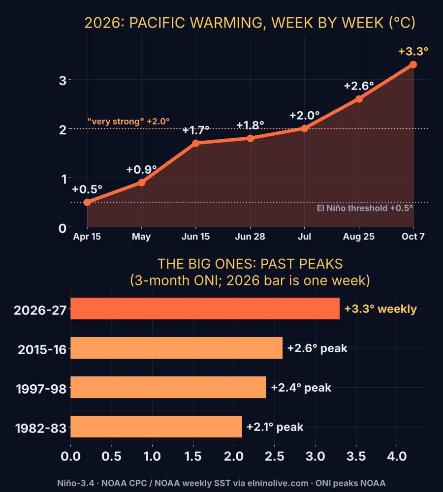
NOAA's Climate Prediction Center confirmed El Niño in July 2026, and each monthly update since has leaned stronger: a Pacific running about 3.0°C above normal by September, and a better than even chance of a very strong or record event. For the Sierra that tilts the odds toward a wetter, warmer storm track: more atmospheric rivers, a higher snow level, rain on snow and flood risk at town elevations, with deep snow up high. It is a tilt, not a guarantee. Every storm still has to be forecast on its own.
October update: NOAA's latest, and what it means for Tahoe
Updated October 24, 2026. NOAA's October 8 ENSO discussion keeps the El Niño Advisory and gives an 83% chance that October to December becomes a historic event, stronger than any El Niño since 1950 on its relative index, with better than 80% odds that a strong or very strong event lasts through January to March 2027. The weekly Niño 3.4 reading reached about +3.3°C in early October. For scale, the famous 1997-98 and 2015-16 events peaked near +2.4°C and +2.6°C on a three month average. NOAA expects the peak in late fall or early winter, then a fade through spring. The next NOAA update is November 12.
NOAA's winter outlook for Truckee and Lake Tahoe
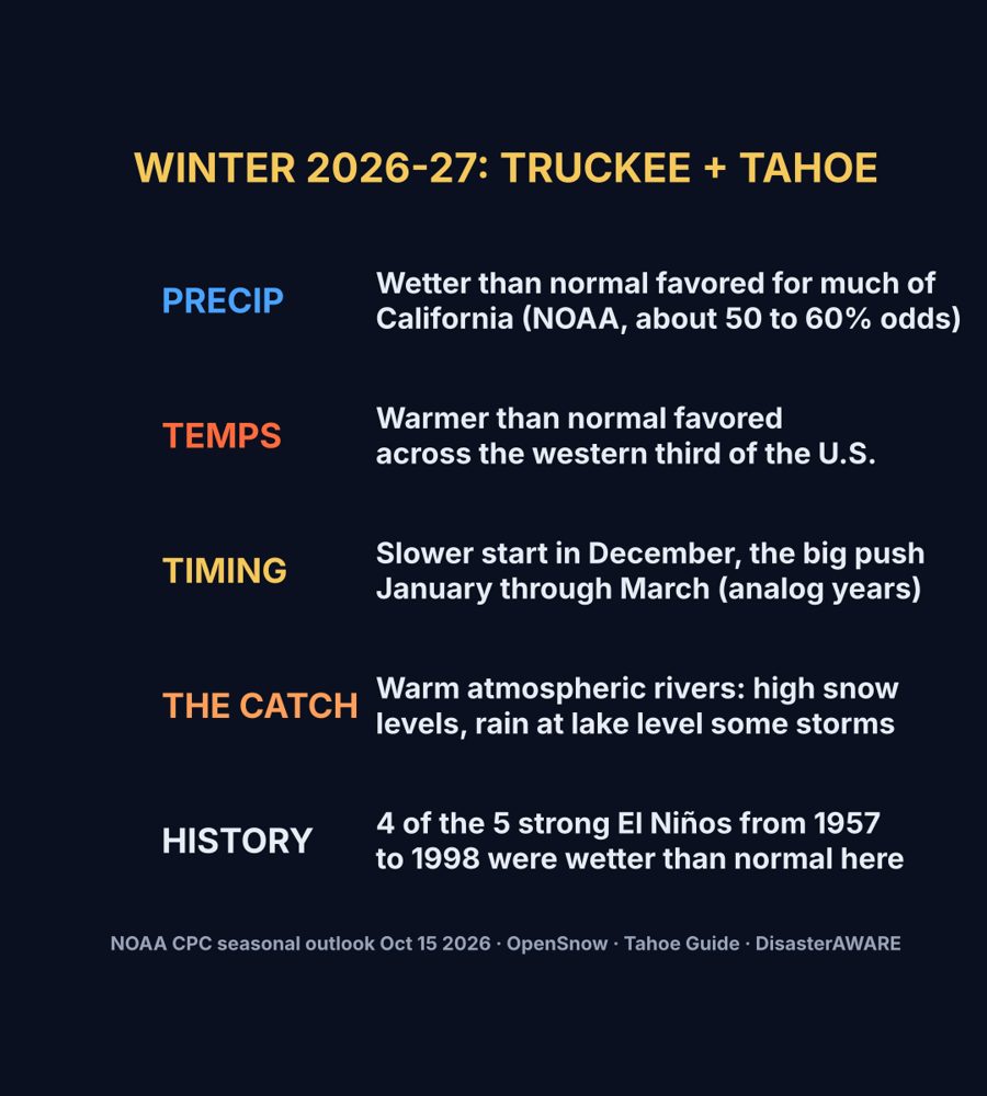
NOAA's seasonal outlook issued October 15 favors above normal precipitation for much of California this winter (roughly 40 to 60% odds, strongest to the south) and above normal temperatures across the western third of the U.S. Its November outlook leans warm for the West Coast and puts Tahoe in equal chances for precipitation. Our projection for Truckee and Tahoe: wetter than normal favored, a little warm, a possibly slow December, and the heart of the season January through March. The catch is warmth: big El Niño storms can arrive warm, with high snow levels and rain at lake level while the mountain gets buried.
How Tahoe did in past strong El Niño winters
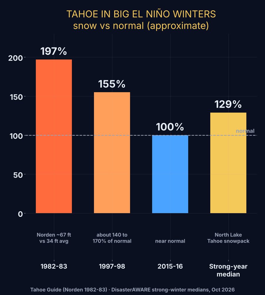
History is encouraging but mixed. In 1982-83 Norden near Donner Pass recorded nearly 67 feet of snow, close to double its 34 foot average. 1997-98 ran roughly 140 to 170% of normal. The last super El Niño, 2015-16, came in near average. Four of the five strong events from 1957 to 1998 were wetter than normal in the Tahoe Sierra, and across the strong El Niño winters the median North Lake Tahoe snowpack is about 129% of normal.
Track each storm as it lines up on the Truckee weather platform, the Palisades Tahoe Ski Day page and the crew GO/NO-GO forecast.
The series, newest first
GODZILLA EL NIÑO: Plus Three and Still Growing
September 26, 2026
The Pacific hit +3.0°C and NOAA gives a 75% chance of a record El Niño. What it means for Tahoe winter and job site prep.
Godzilla El Niño: The Numbers Just Got Real
August 15, 2026
NOAA's August 13 update: 95% chance of a very strong El Niño, 69% chance it beats every event since 1950.
Godzilla El Niño: NOAA Confirms It
July 18, 2026
NOAA confirms El Niño is present, 97% odds through spring 2027, 81% very strong.
Godzilla El Niño
2026
The first post in the series: why this event looks different and what it could do to the Sierra.
What it means on the ground in Truckee
- Snow level matters more than totals. Truckee sits near 5,800 feet, so a storm at 6,000 feet snow level is rain in town and snow on Donner Summit.
- Saturated ground and rain on snow mean drainage, erosion control and storm water work get tested early. See excavation in Truckee and the excavation guide.
- Back to back storms mean more plowing. See snow removal in Truckee.
Follow each storm as it arrives
- Kerr Storm Tracker, errolkerr.com's own future radar built from NEXRAD, HRRR and GFS with a self-grading accuracy loop.
- Truckee weather forecast and the Weather Blog.
- Published forecast accuracy, verified against the Truckee airport station.
- Official outlook: NOAA Climate Prediction Center ENSO discussion.
Questions
What is NOAA's winter outlook for Lake Tahoe in 2026-27?
NOAA's October 15, 2026 seasonal outlook favors above normal precipitation for much of California (roughly 40 to 60% odds, strongest to the south) and above normal temperatures for the western U.S. For Truckee and Lake Tahoe that points to a wetter than normal winter with a risk of warm storms and high snow levels, and the heart of the season January through March.
How much snow did Tahoe get in past strong El Niño winters?
In 1982-83 Norden near Donner Pass recorded nearly 67 feet of snow, close to double its 34 foot average. 1997-98 ran roughly 140 to 170% of normal, and 2015-16 came in near average. Across strong El Niño winters the median North Lake Tahoe snowpack is about 129% of normal.
Is a strong El Niño coming for the 2026-27 winter?
NOAA's Climate Prediction Center confirmed El Niño conditions in July 2026. The series on this page tracks its odds: 97% through spring 2027 in the July update, 95% for a very strong event in the August update, a 75% chance of a record event in the September update, and an 83% chance of a historic event (stronger than any since 1950) in the October 8 update. Check the Climate Prediction Center for the current monthly ENSO discussion.
Does El Niño mean a big snow year in Tahoe?
Not by itself. El Niño tilts the odds toward a wetter and warmer storm track in the Sierra, which can mean more rain at lower elevations, a higher snow level and flood risk, with deep snow at the highest elevations. Each storm still has to be forecast on its own.
What does a wet El Niño winter mean for Truckee crews?
More frequent atmospheric river storms, a snow level that can sit near town elevation, rain on snow, ice on roads and saturated ground. Errol Kerr, a Truckee excavation foreman, uses the series to plan drainage, erosion control and snow removal staffing.
Where can I follow each storm as it arrives?
The Kerr Storm Tracker at errolkerr.com/storms is the site's own future radar built from NEXRAD, HRRR and GFS, and errolkerr.com/accuracy publishes the forecast error against the Truckee airport station.
This is Errol's own forecast guidance. It does not replace the National Weather Service or Caltrans QuickMap road conditions. Avalanche danger comes from the Sierra Avalanche Center; lift and terrain status comes from the resort.